Nahuel Huapi National Park See map
Nahuel Huapi National Park covers 705,000 hectares in the southwest of Neuquén province and northwest of Río Negro province. It was created in 1934 with the aim of preserving a representative area of the northern Andean region of Patagonia.
Tourist activity in the region starts from the creation of this natural reserve.
In its territory there are numerous lakes. The most notable is the Nahuel Huapi. Other lakes of lesser extent are Traful, Espejo and Villarino in the north, Gutierrez, Mascardi, Guillelmo and Steffen in the south.
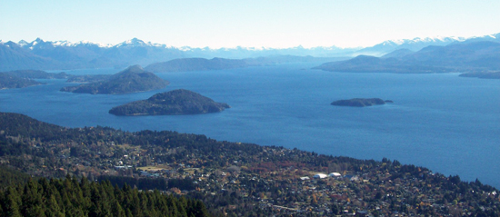
 Lake Nahuel Huapi, the largest of national park. Photo courtesy of Cecilia Rodriguez patagonia.com.ar album
Walks and trails in the park
- Crossing that links the Frey Shelter and General San Martín Shelter. You ride the edge of Cerro Catedral, Rucaco Valley and the ridge of Brecha Negra Hill. Lasts 8 hours and is of medium difficulty.
- Lowered from the General San Martin Refuge along the Casalata river to the area of Hotel Tronador: the route goes through Paso Schweitzer. Lasts 8 hours and is of medium difficulty.
- Drawn from the Segre Shelter and Lopez Sheter to Mount Tronador: through the path that connects the area of Segre and López shelters with Lagoon La Carne. From there you go down to Pampa Linda in Tronador's area. You pass through CAB lagoon, Mallin de las Vueltas and Creton lagoon. The complete tour lasts 2 ½ days and is of medium difficulty.
- Route from Zona Tronador Hotel's area to Lagoon Cretón passing lagoon Azul. To Azul lake, the road has low difficulty and are 3-hour tour. Once there to lagoon Creton the difficulty is medium with a duration of 3 hours.
- Drawn from the watershed to the area of Hotel Tronador at the mouth of the Manso Superior River, through the lake Llum and the edge of Mora Hill. The last part connects with the descent Casalata stream. It last 1 ½ day and has low difficulty.
- Lowering of lagoon La Carne to Pampa Linda. Requires three hours of travel, presenting low difficulty.
- Walk to the bottom of Castaña Overa Valley. The difficulty is low and takes three hours of travel.
- Travel along the road leading Pampa Linda with Lake Frías: you go through the Paso de las Nubes. It requires two days of travel, with low difficulty.
- Path to the Nalcas Saltillo: it starts at 500 meters from the Park Rangers on the way to the base of Tronador Hill. It runs in half an hour.
- Ventisquero Negro Glacier Trail: begins at 7 km from the Park Rangers on the way to the base of Cerro Tronador, reaching the Ventisquero Negro viewpoint.
- Path to the base of Cerro Tronador: starts at the end of the vehicular road, where you can see the Garganta del Diablo waterfall.
- Path to the Lagoon Ilón: it starts at 300 meters from the Park Rangers. It continues towards the Otto Meiling Shelter, until the turning signposted to the right. The ascent takes about six hours.
More information
The quartermaster of the Nahuel Huapi National Park is located in San Carlos de Bariloche.
Adress: San Martín 24, Bariloche
Phone: (02944) 423111
Email: nahuelhuapi@apn.gov.ar
Source: www.parquesnacionales.gov.ar
Alojamiento en San Carlos de Bariloche
 Hotel Selina Bariloche
Selina Bariloche ofrece alojamiento con jardín, estacionamiento privado um lounge compartido y terraza.
Tambiénver másTel: San Carlos de Bariloche
Hotel Selina Bariloche
Selina Bariloche ofrece alojamiento con jardín, estacionamiento privado um lounge compartido y terraza.
Tambiénver másTel: San Carlos de BarilocheViajes por la Patagonia
Related Articles
© Patagonia.com.ar 2025 | Todos los derechos reservados.
