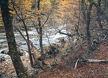
Tierra del Fuego National Park See map
While its natural comformación is not much different from that of its peers, which gives originality to Tierra del Fuego National Park is to be the sole possessor of sea coasts, as its southern boundary is bordered by the waters of the Beagle Channel.
In addition to being representative of the local flora and fauna, the park protects archeological remnants of Aboriginal people Yamana. Another attraction is that within him is the end of National Route 3 and Route Panamericana, in the famous and beautiful Lapataia Bay.
It was created on October 15, 1960, through Law 15 554. It has 63,000 hectares, of which only 2,000, approximately, are designed for recreation and education usage of the population and tourism.
In addition to organized tours you can be carried out within it hiking, camping, fishing, bird watching and water sports on non-motorized vessels, while in winter the area is ideal for cross-country skiing.
Trails and walks in the park
Pampa Alta Trail
Climbing the hill from Pampa Alta from Route 3 about 3 km of the protein in the Park. Besides the view of the surroundings allow you to see an active beaver dam. Degree of difficulty MEDIUM - Length 5km
Pipo River waterfalls
At the end of the road that enters the canyon del Toro (about 5 km from the entrance to the park) starts a path, along the Pipo river, that reaches to the waterfalls of the same. Degree of difficulty: SOFT - Length: 300 m (one way)
Coastal Path

Since the end of the vehicular road that leads to Ensenada Bay, it is a track to the west bordering the Beagle Channel. You can observe marine and coastal birds and different species of trees and shrubs. Consuming around 3:30 hours. Degree of difficulty: MEDIUM - Length: 8km (return)
Paseo de la Isla
Trail that begins after crossing the bridge over Lapataia river, in front of National Guard workstation and which goes through part of the archipelago Cormoranes. Degree of difficulty: SOFT - Length: 1.5 km (one way)
Lagoon Negra
This path of circular route begins after crossing the bridge over the river Ovando, on the right. Well signposted you can observe a peat bog. Degree of difficulty: SOFT - Length: 1km
The circuit Lengas
After the bridge over the river Ovando, on the left. It allows us to see panoramic view of the Lapataia Bay. You can view the Paseo del Turbal. Degree of difficulty: SOFT - Length: 2 km (one way)
Castorera
Path that starts before you reach the end of National Route 3 and that going through the forest you can observe an active beaver succession. Degree of difficulty: SOFT - Length: 200 m (one way)
Milestone XXIV
8 km from the front of the park and past the parking lot of Lake Roca begins this path that goes to the Hito XXIV which marks the border between Argentina and Chile. Consuming approximately 3 hours. Degree of difficulty: SOFT - Lontitud 5 km
Guanaco Hill
The trail starts along with the one leading to Milestone XXIV, but it ascends steeply to the right after crossing the first stream. Takes approximately 4 hours. Degree of difficulty: DEMANDING - Length 8 km. (Round)
Very important recommendations in the Park
* Outside the National Route 3 and the complementary ways, is strictly prohibited the movement of all vehicles.
* The maximum speed once you has entered the Park is 40 km/hour.
* If you want to fish, you must take into account that both the start and the end dates of the season, as a permit. They are different from the rest of the province.
* Removal of mussels and bivalve molluscs is prohibited by the presence of red tide (a disease affecting fish in this area and that can cause death in humans).
* Do not perform any registration in rocks, trees, etc.
* Hunting and weapons charges are subject to SEVERE PENALIZATIONS
* Do not dispose of waste. Place them in a bag and bring them back to the city.
* In the Lake Roca area is recommended to boil the water for 5 minutes before drinking.
The superintendency of the Park is based in Ushuaia (Calle San Martín 1395).
Alojamiento en Ushuaia
 Departamento La Vela
El alojamiento independiete la Vela está situado en Ushuaia, a solo 400 metros del Casino Club Ushuaia y a 900 metrosver másTel: Ushuaia
Departamento La Vela
El alojamiento independiete la Vela está situado en Ushuaia, a solo 400 metros del Casino Club Ushuaia y a 900 metrosver másTel: UshuaiaViajes por la Patagonia
Related Articles
© Patagonia.com.ar 2025 | Todos los derechos reservados.
